
We’re very lucky to live close to both Ceredigion and Pembrokeshire Coastal paths however until recently we hadn’t accessed them. Since Pip joined the family eight weeks ago we have decided that this will change and are making a start on exploring the coastal path. The walk I am sharing with you below starts from one of our favourite beachs, Poppit Sands and takes you further up the coast to Camaes Head. We then opted to leave the Coastal footpath and follow another footpath inland again and back to where we started. It is a walk that is very popular locally with ramblers and dog walkers alike. I also choose to share this walk recently when asked to write a piece showcasing the Best Dog Walks in Pembrokeshire.
Distance 5miles/2 hours
Terrain: Several long uphill sections. Certain stretches may become very muddy or boggy in heavy rain.
The Pembrokeshire Coastal Path covers 186 miles of coast taking in breath taking scenery along the route. The path stretches from St Dogmaels in the North to Amroth in the South. The Pembrokeshire Coastal Path lays almost completely within the Pembrokeshire Coast National Park which is Britain’s only coastal National Park. From sheltered coves, exposed cliff tops to estuaries and wide expanses of beach the coastal path is quite a challenge. With gorgeous coastal flowers, bird life and marine wildlife there is lots to soak up.
This walk takes us from Poppit Sands, near St Dogmaels up to Cemaes Head then leaves the Coastal Footpath back inland via footpaths and bridle ways back to Poppit Sands (route 2 on the map)
 Start: Poppit Sands Carpark, St Dogmaels, SA43 3NL
The walk starts from the public car park at Poppit Sands. Exit via the path next to Poppit Sands Café and follow the road round to the left following the signs for the Youth Hostel and Coastal Path. It is a steep single track road with lovely views over Poppit Sands. There are several footpaths leading off this route which provide the option to head inland. This is the first time we’ve done this walk and its the first long walk our new puppy Pip (a miniature dachshund) on this walk with us and he’s keen to get going. We also have my dad and his dog Charlie (a King Charles spaniel) with us for the walk and Charlie quickly sets the pace with Pip following him excitedly. Everyone is in good spirts and the sun has come out after several overcast and miserable days.
1.5 mile
From the cattle grid at Allt-y-Coed there is a seasonal campsite and the chance to catch your breath and take in the view. There are the option of taking a footpath around the back of Allt-y-Coed which joins the coastal path again but saves from descending along the path and climbing steeply again. We take this diversion when we have the children with us. We stop briefly to take in the view and enable the dogs to have a rest.

Cardigan Island
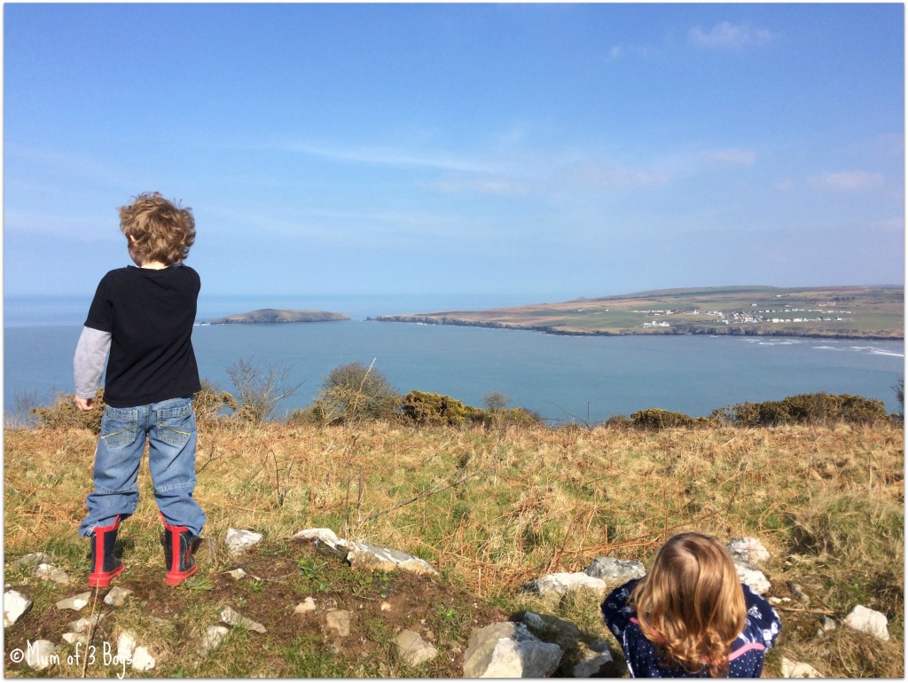
Up to this point we have caught glimpses of Poppit below us and Cardigan Island across the bay.

Poppit Sands
I expected Pip to struggle with the climb but he coped really well. Setting off again the coastal path now winds its way to Cemaes Head and around the Headland through a stile. It is mainly gentle gradients and horses graze the land. A second stile is situated at the top of the Headland. From here the path is extremely close to the cliff edge and caution is needed especially with young children in tow. My dad walks in the front with Charlie with my six and ten year olds closely behind him with myself, Pip, Erin and dad of 3 bringing up the rear. I wouldn’t advise walking this section in high winds as it’s very close to the edge in places.
2 miles

Old Coastguard Lookout Hut
The Old Coastguard Lookout Hut stands like a silent guardian watching the sea. Just passed this there is a third stile which takes you further along the coastal path giving you views over the coastline towards Newport.

Views to of the Pembrokeshire Coastline
It’s at the old Coastguard Lookout that I take the decision to put Pip in his carry bag to rest for a bit, he’s surprised us all by walking all the way so far but I’m wary he needs a break. He happily climbs in and enjoys a treat as we continue along the path.
 There are views of small coves below the cliffs. Again there are sections that are close the edge which then climb upwards to a fourth stile. Another chance to stop and take in the views. It is at this stile that we leave the Pembrokeshire Coastal Path and start heading inland along a footpath.
2.50 miles
Through two stiles in quick succession onwards into more farmland along the footpath. At the end of this section you have the option to bare left and follow a Bridle path taking you back towards the Coastal Path emerging some 0.3 below Allt-y-Coed. However we bared right and followed the Bridle Path towards Pengarn-Fach. A relatively flat terrain through more fields passed a look out point with views. Half way down the bridle path there is a view point with gorgeous views over the fields and Poppit Sands in the distance. We stop here for a drink and some chocolate and offer the dogs a treat and water. After ten minutes we continue on down the bridle path until the path forks and we take the right fork. Now away from the cliff edge the children are more relaxed and happily run on ahead of us enjoying the freedom and the space.

3.25 miles
The bridle path here is well trodden and there are lots of fresh hoof prints. The path is descending and is quite steep in places and the ground uneven due to the horses using it so care is needed. As we look across the valley we can see what looks like a converted church in the fields opposite.
 As we continue along we come across Bryn Salem. A carpet of snowdrops surround the sleeping chapel. We make our way round to the door and peer inside, long abandoned Bryn Salem has tales to tell of sermons once held there. The floors are rotten inside so caution is needed. Charlie was reluctant to leave, he seemed to have found the scent of something and was having a good nose around. Bryn Salem has a rich history dating from 1852 when the building was completed. Several Ministers have preached there over the years which saw a new organ being installed on 26th December 1929. Extensive repairs have also been carried out which saw the Chapel reopening on 21st May 1948. The last known Minister of Bryn Salem was Rev. Llungwyn O Jones who died in May 1984. Following this the chapel feel into disrepair and became derelict.

Bryn Salem

Bryn Salem and Snowdrops

View from the front of Bryn Salem
4 miles
Turning left at the end of the path the Bridle path continues down to Cippyn Fawr which then joins a narrow country lane before joining a slightly wider country road. You are still walking downhill and a leisurely pace can be enjoyed.
 Care is needed with traffic as the road is narrow in places. As we approach the main road Pip starts barking and trying to get out of his bag, it seems his rest did him good and he now wants to walk again. So I put him down and he quickly moves up to where Charlie is walking and walks alongside him. We had to stop and move into the verge a couple of times due to oncoming traffic. You can make out the River Teifi in the distance and there is a popular caravan site located in a dipped valley which runs just before road level.

View of the Estuary
Then Poppit car park comes into site again with the promise of a welcome cup of tea in the café or an ice cream maybe.
5miles
We reach the car park and our cars having all thoroughly enjoyed the walk. It opened our eyes to new places on our doorstep with more possibilities for further walks in the future. We completed the walk in just over two hours with a couple of stops along the way.
Great article and wonderful photos; sounds like the whole family had a ball. Where can I get the map from that you featured at the beginning of your piece?
Hi Tim, you should be able to get it from any tourist information office in Pembrokeshire